This statue of Jesus stands some 38 meters tall, atop the Corcovado
mountain overlooking Rio de Janeiro. Designed by Brazilian Heitor da
Silva Costa and created by French sculptor Paul Landowski, it is one of
the world’s best-known monuments. The statue took five years to
construct and was inaugurated on October 12, 1931. It has become a
symbol of the city and of the warmth of the Brazilian people, who
receive visitors with open arms.
Content
Showing posts with label Brazil. Show all posts
Ouro Preto
Ouro Preto (from Portuguese, Black Gold) is a city in the
state of Minas Gerais, Brazil, a
former colonial mining town located in the Serra do Espinhaço mountains and
designated a World Heritage Site by UNESCO
because of its outstanding Baroque architecture.
Founded at the end of the 17th century, Ouro Preto (meaning Black Gold) was originally called Vila Rica, or "rich village", the focal point of the gold rush and Brazil's golden age in the 18th century under Portuguese rule.
The city contains well-preserved Portuguese colonial architecture, with few signs of modern urban life. Modern construction must adhere to historical standards maintained by the city. 18th- and 19th-century churches decorated with gold and the sculptured works of Aleijadinho make Ouro Preto a prime tourist destination.
The tremendous wealth from gold mining in the 18th century created a city which attracted the intelligentsia of Europe. Philosophy and art flourished, and evidence of a baroque revival called the "Barroco Mineiro" is illustrated in architecture as well as by sculptors such as Aleijadinho, painters such as Mestre Athayde, composers such as Lobo de Mesquita, and poets such as Tomás António Gonzaga.
In 1789, Ouro Preto became the birthplace of the Inconfidência Mineira, a failed attempt to gain independence from Portugal. The leading figure, Tiradentes, was hanged as a threat to any future revolutionaries.
In 1876, the Escola de Minas (Mines School) was created. This school established the technological foundation for several of the mineral discoveries in Brazil.
Ouro Preto was capital of Minas Gerais from 1720 until 1897, when the needs of government outgrew this town in the valley. The state government was moved to the new, planned city of Belo Horizonte.
Read more »
Founded at the end of the 17th century, Ouro Preto (meaning Black Gold) was originally called Vila Rica, or "rich village", the focal point of the gold rush and Brazil's golden age in the 18th century under Portuguese rule.
The city contains well-preserved Portuguese colonial architecture, with few signs of modern urban life. Modern construction must adhere to historical standards maintained by the city. 18th- and 19th-century churches decorated with gold and the sculptured works of Aleijadinho make Ouro Preto a prime tourist destination.
The tremendous wealth from gold mining in the 18th century created a city which attracted the intelligentsia of Europe. Philosophy and art flourished, and evidence of a baroque revival called the "Barroco Mineiro" is illustrated in architecture as well as by sculptors such as Aleijadinho, painters such as Mestre Athayde, composers such as Lobo de Mesquita, and poets such as Tomás António Gonzaga.
In 1789, Ouro Preto became the birthplace of the Inconfidência Mineira, a failed attempt to gain independence from Portugal. The leading figure, Tiradentes, was hanged as a threat to any future revolutionaries.
In 1876, the Escola de Minas (Mines School) was created. This school established the technological foundation for several of the mineral discoveries in Brazil.
Ouro Preto was capital of Minas Gerais from 1720 until 1897, when the needs of government outgrew this town in the valley. The state government was moved to the new, planned city of Belo Horizonte.
Iguazu Falls
Iguazu Falls, Iguassu Falls, or Iguaçu Falls (Portuguese: Cataratas do Iguaçu [kataˈɾatɐz du
iɡwaˈsu]; Spanish: Cataratas
del Iguazú [kataˈɾatas ðel iɣwaˈsu]; Guarani: Chororo
Yguasu [ɕoɾoɾo
ɨɣʷasu]) are waterfalls
of the Iguazu River located on the border of the
Brazilian State of Paraná and the Argentine Province of Misiones. The falls divide the river into the upper and
lower Iguazu. The Iguazu River originates near the city of Curitiba.
It flows through Brazil for most of its course. Below its confluence
with the San Antonio River, the Iguazu River forms the boundary between
Brazil and Argentina.
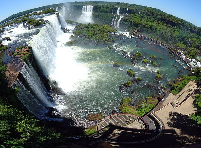
Union Fall, Iguazu's largest cataract
The name "Iguazu" comes from the Guarani or Tupi words y [ɨ], meaning "water", and ûasú [waˈsu],
meaning "big".[2]
Legend has it that a god planned to marry a beautiful woman named Naipí,
who fled with her mortal lover Tarobá in a canoe. In rage the
god sliced the river, creating the waterfalls and condemning the lovers
to an eternal fall.[2]
The first European to find the falls was the Spanish Conquistador
Álvar Núñez Cabeza de Vaca in
1541
Iguazu Falls is located where the Iguazu River tumbles over the edge of the Paraná Plateau, 23 kilometres (14 mi) upriver from the Iguazu's confluence with the Paraná River. Numerous islands along the 2.7-kilometre (1.7 mi) long edge divide the falls into numerous separate waterfalls and cataracts, varying between 60 metres (200 ft) and 82 metres (269 ft) high. The number of these smaller waterfalls fluctuates from 150 to 300, depending on the water level. About half of the river's flow falls into a long and narrow chasm called the Devil's Throat (Garganta del Diablo in Spanish or Garganta do Diabo in Portuguese). The Devil's Throat is U-shaped, 82-meter-high, 150-meter-wide, and 700-meter-long. Placenames have been given also to many other smaller falls, such as San Martin Falls, Bossetti Falls and many others
About 900 meters of the 2.7-kilometer length does not have water flowing over it. The edge of the basalt cap recedes by 3 mm (0.1 in) per year. The water of the lower Iguazu collects in a canyon that drains in the Paraná River, a short distance downstream from the Itaipu Dam. The junction of the water flows marks the border between Brazil, Argentina, and Paraguay. There are points in the cities of Foz do Iguaçu, Brazil, Puerto Iguazú, Argentina, and Ciudad del Este, Paraguay, which have access to the Iguazu River where the borders of all three countries can be seen, a popular tourist attraction for visitors to the three cities
Read more »
Iguazu Falls is located where the Iguazu River tumbles over the edge of the Paraná Plateau, 23 kilometres (14 mi) upriver from the Iguazu's confluence with the Paraná River. Numerous islands along the 2.7-kilometre (1.7 mi) long edge divide the falls into numerous separate waterfalls and cataracts, varying between 60 metres (200 ft) and 82 metres (269 ft) high. The number of these smaller waterfalls fluctuates from 150 to 300, depending on the water level. About half of the river's flow falls into a long and narrow chasm called the Devil's Throat (Garganta del Diablo in Spanish or Garganta do Diabo in Portuguese). The Devil's Throat is U-shaped, 82-meter-high, 150-meter-wide, and 700-meter-long. Placenames have been given also to many other smaller falls, such as San Martin Falls, Bossetti Falls and many others
About 900 meters of the 2.7-kilometer length does not have water flowing over it. The edge of the basalt cap recedes by 3 mm (0.1 in) per year. The water of the lower Iguazu collects in a canyon that drains in the Paraná River, a short distance downstream from the Itaipu Dam. The junction of the water flows marks the border between Brazil, Argentina, and Paraguay. There are points in the cities of Foz do Iguaçu, Brazil, Puerto Iguazú, Argentina, and Ciudad del Este, Paraguay, which have access to the Iguazu River where the borders of all three countries can be seen, a popular tourist attraction for visitors to the three cities